Enregistrez gratuitement cette image
en 800 pixels pour usage maquette
(click droit, Enregistrer l'image sous...)
|
|
Réf : T01264
Thème :
Terre vue de l'espace - Volcans (181 images)
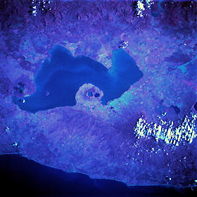
Titre : Lake Managua, Nicaragua October 1989
Description : (La description de cette image n'existe qu'en anglais)
Lake Managua, a large freshwater lake approximately 40 miles (65 kilometers) long and 15 miles (25 kilometers) wide, is the centerpiece of this near-vertical, color infrared photograph. The lake empties via the Tipitapa River into much larger Lake Nicaragua (not part of this photograph) to the southeast. The capital city of Managua, with a population of more than 500 000, is located along the southern shore of Lake Managua, the area with the highest population density in Nicaragua. The key to understanding the physical setting of Lake Managua is to note the numerous volcanic features aligned in a northwest-southeast axis. Momotombo, a stratovolcano, is located on the northwest end of the lake, and two water-filled calderas (Apoyegue and Jiloa volcanoes) are easily discernible on the Chiltepe Peninsula, which protrudes into Lake Managua. Two major earthquakes (1931 and 1972) devastated the Managua area. In addition to occasional volcanic activity, a crustal fracture (structural rift valley) has created a long, narrow depression east of the volcanic zone and west of the main body of mountains. This very active, unstable geologic area is the result of the subduction of the Cocos Plate by the Caribbean Plate.
|
|

